History of the Assabet River NWR
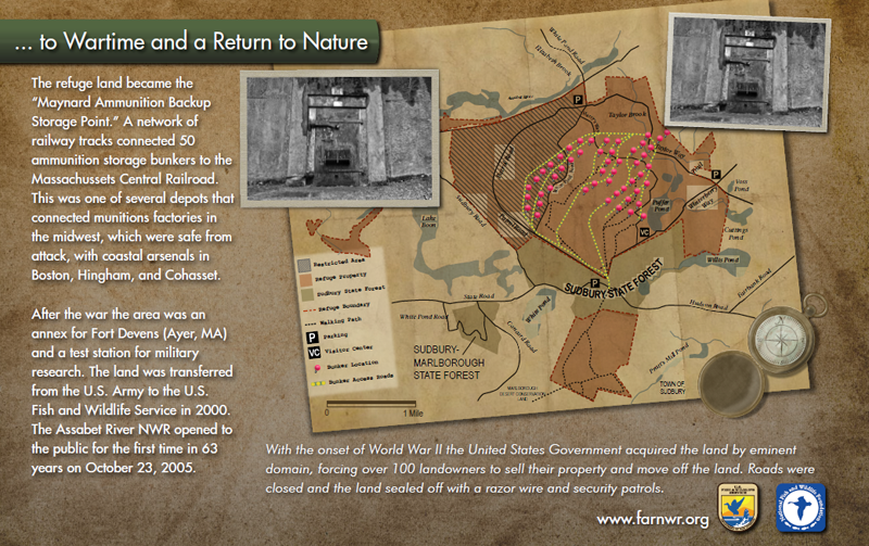
The property, once known as the Fort Devens Sudbury Training Annex, had been placed off-limits by the Army since 1942 when they acquired it for an ammunition storage facility. Before World War II, the area consisted of small family farms and wood lots, some dating back to colonial times.
Assabet River NWR was established on September 28, 2000 when the U.S. Army transferred 2,230 acres to the U.S. Fish and Wildlife Service to be part of the National Wildlife Refuge System. The refuge opened to public access in March of 2005, followed by an official Dedication and Ribbon Cutting Ceremony on October 23, 2005.
The refuge's specific objectives are determined in the Comprehensive Conservation Planning process. The objectives include the conservation and management of migratory bird species; the restoration of wetland, grassland and forest habitats; and natural resource related education. Potential public uses of the refuge include wildlife observation, photography, environmental education, interpretation, hunting and fishing.
The Friends are pleased to have raised grant funds from the National Fish and Wildlife Foundation (NFWF) for the design and construction of information panels that summarize the history of the Refuge. The panels are installed on Harry's Way just outside the visitor center to tell the fascinating history of this area.
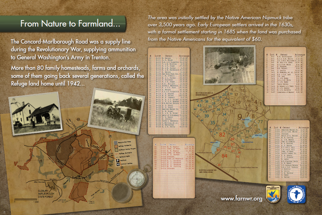
The panel shows the land ownership and the individual landowners and the acreage at the time the land was taken by Eminent Domain in 1942. Note that one of the landowners listed is Henry Ford who had bought land in the vicinity. Also note that archaeological excavations on the Refuge undertaken since these panels were created suggest that the area now occupied by the Refuge was settled at least 7,500 years ago (not 3,500 years ago).
Members of several families who had grown up on the land before it was taken by Eminent Domain attended the grand opening of the Visitor Center in 2010. Notable were members of the Carbary family who moved to the area in 1926. The chimney of the Carbary home can still be seen off Carbary Way.
The Friends owe a big thank you to Barbara Volkle (founding President of the Friends), Tim Prior (former Refuge Manager), Jan Wright and Maynard Town Historian Paul Boothroyd (both former board members of FARNWR) who conceived the idea, wrote the NFWF grant and spent many hours doing meticulous research and gathering information for the panels. Dave Griffin (President of the Maynard Historical Society) and Betsy Griffin (past President of the Friends) coordinated the project to its completion. Southern Customs Exhibits of Alabama designed and constructed the panels.
Notes on the History of the Refuge and the Origin of the Trails
Eastern Massachusetts, particularly near waterways such as the Assabet, Sudbury and Concord Rivers was initially settled over 10,000 years ago. Archaeological remains from the pre-contact period have been located in the refuge near Puffer Pond. The earliest remains are from the Middle Archaic period dating to approximately 5000 BCE.
When the Puritan settlers arrived in the 1630's, clans of the Nipmuc lived in area though by the time of the settlement of Sudbury in 1638, disease had substantially reduced the population. In 1654, the western part of what is now the Refuge became part of the Okommakamesit (Okkokonimesit) settlement for "praying Indians". The name "Assabet" is likely from the Nipmuc dialect though the exact meaning of the word is uncertain. It seems to refer to the marshy nature of the area alternatively described as meaning “the place where materials for making fishnet grows”, “a mire-y place”, and “at the place where the river turns back.”
The area was settled by the Puritans in 1649 by the third grant of land known as the “Two mile Grant”. This lot of two miles encompassed the territory from a line drawn approximately through Willis Pond and the Sudbury White Pond to the Assabet River. In March 19th, 1685 the land was purchased from the Native Americans for 12 British Pounds, the equivalent of 60 US Dollars. From the 1600's through the 1940's, the area consisted of small family farms, homesteads and woodlots.
In 1942 the US Government chose the area for use as an ammunition storage and testing site. The location was in close proximity to Boston (25 miles) but safe from attack; was serviced by the little used Mass Central Railroad line and contained an abundance of marshland to absorb the effects of explosions. The Government initially bought and took some farms by Eminent Domain. The storage area became known as the Ammunitions Dump or the “Ammo Dump”.
Subsequently, from the 1950’s to the 1980’s the US Military used it for a variety of purposes. Most recently it was managed under Fort Devens and used for troop training for Desert Storm.
The Friends played a major role in the lobby to set aside the land for a National Wildlife Refuge and over a five year period our members removed hazards such as razor wire to make the refuge safe for the public. From a derelict Army site, friends have transformed the Refuge in to a thriving place for wildlife and the public by lobbying for the Eastern Mass. Visitor Center to be located in the refuge.
Many of the trails have their origin as part of the ammunition depot and in the farm country before that. In addition, the trails and the surrounding land have a rich history since colonial times when it was first settled. This includes the War of Independence and the thriving urban community around the Woolen Mill in Maynard in the 1800’s.
Information on the history of the refuge is courtesy of Paul Boothroyd of the Maynard Historical Society and Friends of Assabet River NWR.
You’ll find more history notes on some specific trails over on the Trails page.